Widgetized Section
Go to Admin » Appearance » Widgets » and move Gabfire Widget: Social into that MastheadOverlay zone

Risk and the Biggert-Waters Act
A note for our readers: the views reflected by the authors do not reflect the views of ASPA.
By William L. Waugh, Jr.
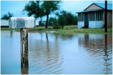 The Biggert-Waters Flood Insurance Reform Act of 2012 (Biggert-Waters) was a response to the long-standing issue of how to deal with development on floodplains. It was also a response to the long-standing criticism of the National Flood Insurance Program (NFIP) for encouraging development in hazardous areas by underwriting the cost of insurance. Under NFIP, the cost of flood insurance had not been commiserate with the risk posed by flooding and the Biggert-Waters Act was expected to address that issue. But in March 2014, President Obama signed the Homeowners Flood Insurance Affordability Act (HFIAA) which repealed the insurance rate increases mandated by Biggert-Waters that sometimes ran to 1000 percent. The $24 billion deficit that Biggert-Waters was supposed to reduce is now sure to rise when the hurricane season begins May 1.
Clearly, Biggert-Waters had a big impact upon the Hurricane Sandy recovery and on the real estate markets around the United States. Property owners often saw significant increases in the cost of flood insurance and encountered difficulty selling property subject to the higher rates. In terms of the Hurricane Sandy recovery, the first issue had been the redrawing of flood zones when the storm surge inundated areas not previously thought vulnerable. Much the same happened following the Katrina disaster on the Gulf coast. As a November 2013 National Academy of Public Administration study pointed out, accurate flood mapping is critical. Given expected weather shifts and sea level rise, the problem of flooding along America’s shores will increase and planning necessarily has to anticipate changes in floodplains decades into the future.
In order to qualify for disaster assistance, property owners have been asked to comply with NFIP requirements to reduce exposure to future storm surge – meaning the requirement to elevate their homes at least a foot above the 100-year floodplain. For a two-story house, the second floor might be out of the floodplain. However, the first floor, unless elevated, would not likely be and disaster aid will not be available. The expense of rebuilding escalated tremendously. This is not new. Much of the foot-dragging in the redevelopment of New Orleans and along the Mississippi coast after Katrina’s landfall was due to the floodplain issue. Much of the city in New Orleans was below sea level and subject to flooding. Before Katrina, emergency managers joked that homeowners kept axes in their attics so that they could cut their way out when the floods came. It was not as clear that storm surge would have such an impact upon coastal communities in Mississippi. A series of articles in Administration & Society in 2009 focused on the conflicts with insurance companies over whether the damage was due to wind or water, as many residents did not have flood insurance to cover water damage.
The 100-year flood rule still means that a property has a 1 percent probability of flooding every year. That is a statistical probability and areas can experience many 100-year floods in one year or none. Indeed, an American Rivers study determined that the biggest problem is that the same properties tend flood over and over again. Repetitive flooding means that the same properties receive flood insurance monies multiple times. While buyouts have been the preferred method of removing homes and businesses from floodplains, there is a history of property owners simply rebuilding in the same locations repeatedly – at NFIP expense.
What is the answer? Who should pay? Should the NFIP continue to underwrite development in hazardous areas, thus putting people and property at risk? Historically the focus has been on 100-year floodplains, but larger floods are getting to be more common. Communities just east of Atlanta experienced what has been estimated to be a 10,000-year flood in 2009. Subdivisions were flooded. Sections of Interstate 20 were flooded. Bridges were damaged. Areas of the Metro area that had no history of flooding were nonetheless flooded. There was unusually heavy rainfall that affected other parts of the Southeast as well. But, reviews determined that part of the problem was communities were making land-use decisions without consulting surrounding communities and the result was the diversion of run-off onto neighboring properties. The lesson is that flood mapping is critical and comprehensive regional flood mitigation planning should be a part of that process.
The issue of how to deal with risk is certainly not new. Development in coastal areas, along rivers and lakes, in picturesque mountain areas and in desert areas subject to flashfloods is as old as human settlements. Indeed, there often is reason to be in such environs. In some measure, we have accepted such development when individuals were putting themselves at risk. It has become more problematic and legally contentious when individuals have increased the risk to their neighbors or the community at large, as happens when property owners damage sand dunes or wet lands that block or absorb storm surge. Communities have often been unsuccessful in their attempts to regulate coastal development when such regulation may reduce the value of property to its owners. However, more communities are reluctant to approve public funding for beach replenishment when new sand may only be washed away in the next storm or the new beach configuration might increase risk to other properties. Biggert-Waters underscored the problem when taxpayers were helping to finance such risky behavior. The effort to make the NFIP financially sound by matching insurance rates and risk was seen by many as a first step toward.
If we want to make flood insurance affordable and, at the same time, reduce our exposure to flood damage, the key is to limit rate increases per year or per multi-year period to reduce the sticker shock. That will not necessarily reduce the vulnerability of communities to flooding, because the built environment generally changes very slowly – unless a major disaster provides opportunity for redevelopment. Changing development patterns will mean changing the land-use planning process to make local officials more sensitive to risk and perhaps less sensitive to pressure brought by developers and property owners.
The American Planning Association recommends linking local comprehensive planning and hazard mitigation planning. In some measure, the NFIP offers one of the few regulatory vehicles to shape development on floodplains. If the Federal Emergency Management Agency’s maps are accurate, anticipate changes in flood hazard and the program requires stronger community mitigation measures to reduce flooding – the current options under the Community Rating System permit minimal efforts to reduce losses and those options may be made more substantial. Stronger state action to assure effective local land-use planning to reduce losses would also help. Ultimately, buyouts may be the quickest means of removing properties from hazardous areas while guaranteeing that property owners do not suffer financial loss. New York State has taken this course as part of its Hurricane Sandy recovery and New Jersey has relied on local communities to manage their own recoveries with some federal and state help. When the next storm comes ashore, we should know which strategy works best.
Hurricane Sandy has raised a good many questions, including questions about the vulnerability of urban populations, communications infrastructure, hospitals, mass transit systems and warning systems. The impact of sea level rise was amply demonstrated and on a grand scale. Many of the same risk management issues have been evident in the recent Washington State landslide, the urban wildfires in the West, and the recent hazardous materials incidents in West Virginia, North Dakota, Arkansas and other states. Understanding the risks and effectively addressing them is a challenge at all levels of government.
Author: William L. Waugh, Jr. is Professor Emeritus in the Department of Public Management & Policy at Georgia State University. He can be reached at [email protected].
 (1 votes, average: 5.00 out of 5)
![]() Loading...
Loading...
Follow Us!